Image 1 Overhead view of fountain in Pacific House.

Image 2 Pacific Basin Fountain apparently in process of being installed. Note Edgar Taylor stained glass map being installed behind scaffolding. Pacific House, 1939.
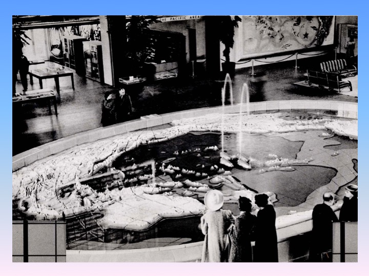
image 3 Pacific Basin Fountain in main lobby of Pacific House, 1939–note spouting whales in center of fountain and Covarrubias mural at the top right of photo

Image 4 Photo of Antonio Sotomayor painting caricatures (brush is on his wife, Grace)

image 5 Antonio Sotomayor self-portrait (in hand-painted Pacific House booklet)

Image 6 Miguel Covarrubias posing with “Flora and Fauna of the Pacific”

Image 7 Court of Pacifica, 1939 (Gabriel Moulin photo)
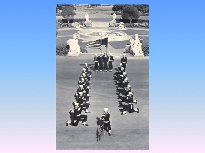
Image 8 Navy Electronics School has its picture taken in the Court of Pacifica (1953)

Image 9 Overhead image, Court of Pacifica, date unknown (post 1942)
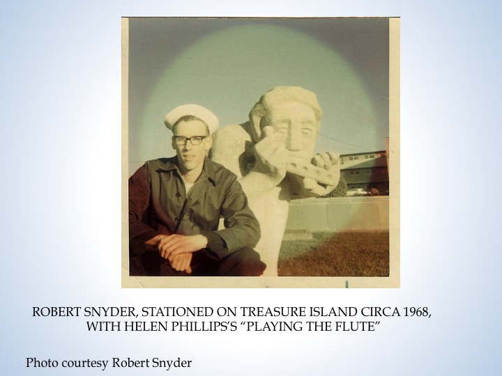
Image 10 Sailor Bob Snyder and Helen Phillips sculpture, circa 1968

Image 11 Adaline Kent sculpture, Court of Pacifica, circa 1992

Image 12 Sargent Johnson sculpture, Court of Pacifica, circa 1992
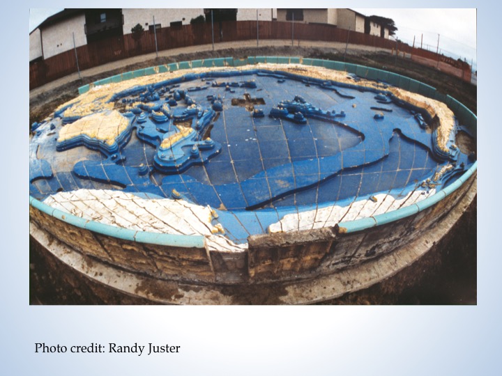
Image 13 Intact fountain circa 1991
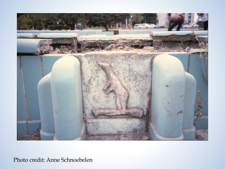
Image 14 Detail of fountain
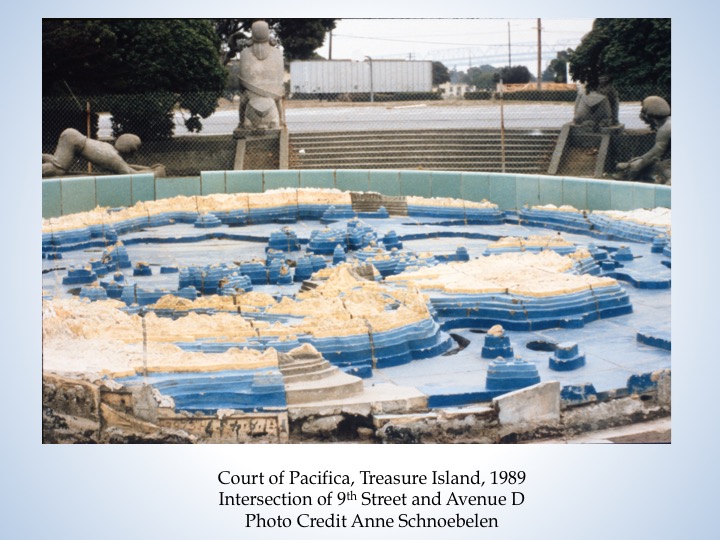
Image 15 Detail of fountain and sculptures in Court of Pacifica. Note staircase–fountain is on a plaza that is below grade

Image 16 Detail of fountain

Image 17 Blue-sky plan for sculpture garden on Treasure Island featuring Sotomayor fountain and Court of Pacifica sculptures

Image 18. Photograph of fountain taken shortly before it was dismantled.
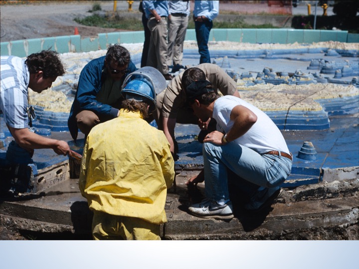
Image 19 The fountain being dismantled
The Pacific Basin Fountain
A History and Description
By Anne Schnoebelen
Pacific House, Golden Gate International Exposition, 1939-1940
Created in 1938 at Gladding McBean, Lincoln, California
Glazed terra cotta, 950 square feet, 361 sections
Width at equator: 43’2”
Center meridian; 27’2’
Perimeter wall: 114 linear feet
Weight: 30 tons (estimated)
Colors: Shades of blue, brown, yellow, green, white, aqua
The relief map of the Pacific Basin was designed by San Francisco artist Antonio Sotomayor and architect Philip Newell Youtz, and executed in 1938 and 1939 by Sotomayor and assistants at Gladding McBean and Company (GMcB) in Lincoln, California. It is oval in shape and approximately the size of a backyard swimming pool. When installed in Pacific House at the Golden Gate International Exposition, it was filled with water and served as a fountain. [Image 1]
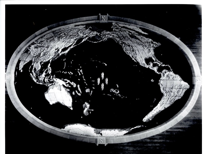
The relief map represents the islands, continents and waters of the Pacific, hand modeled in great detail. The highest mountain peak is approximately 16 inches higher than the lowest ocean trench. Lines of latitude and longitude are represented by the joints between the map’s 361 individual sections. Four three-dimensional ceramic whales, approximately 25 inches in length and covered with a teal glaze, spouted at the center of the fountain just north of Hawaii. The map itself is surrounded by a perimeter wall, approximately two feet in height and eight inches wide, finished with an aqua glaze. Compass points are marked with a compass rose and the letters N, S, E and W on the top surface of the wall. On the vertical exterior surface of the wall at each compass point is an animal figure in low relief.
A Fountain of the Pacific for the Pageant of the Pacific
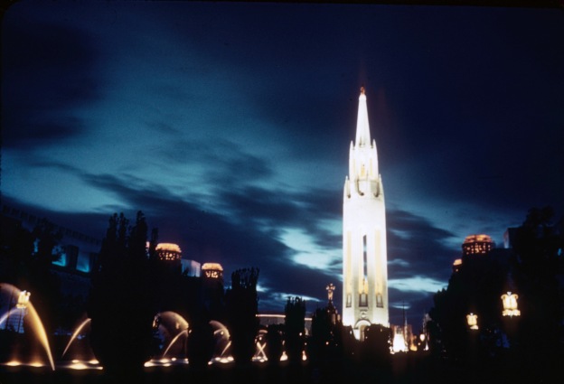
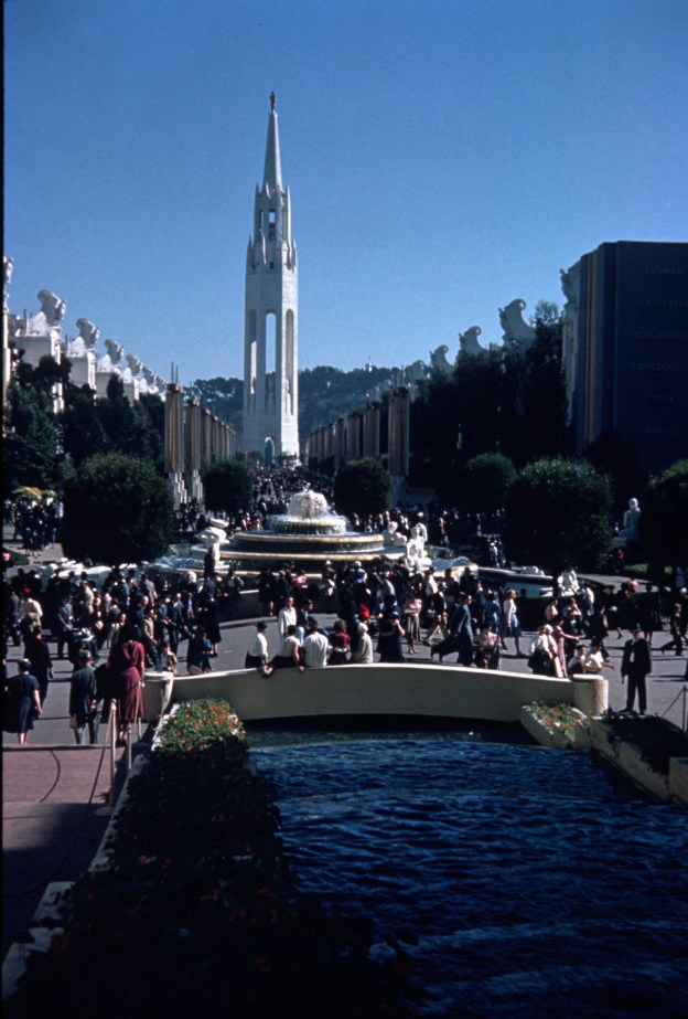
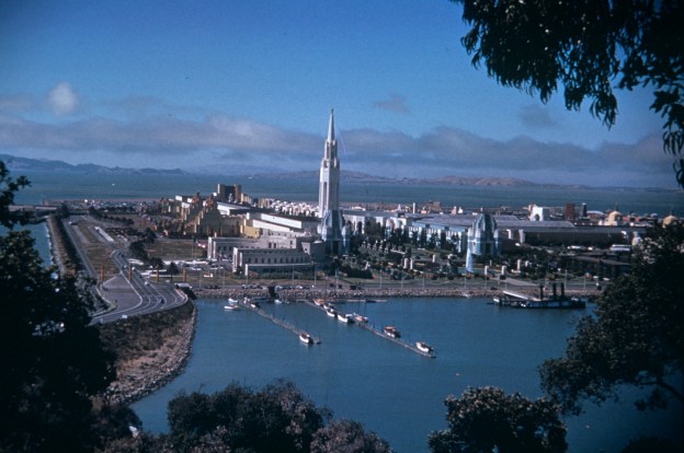
The map was displayed in Pacific House, the “theme building” of the Golden Gate International Exposition on Treasure Island in 1939 and 1940—“The Pageant of the Pacific.” The man-made island itself was initially conceived as the site of an airport which would serve Pan American Airways trans-Pacific “Clipper” flying boats, the first commercial, regularly-scheduled air transport between the United States and Asia. The fair’s theme, “Pacific Unity,” celebrated peaceful interdependence among the countries of the area that we now call the Pacific Rim. Pacific House, designed by architect William Merchant, was the central building of the fair’s “Pacific Area” where most of the Pacific countries participating in the fair had their pavilions. The inauguration of air travel to Asia helped spark the fair’s theme.
But it was the influence of the local chapter of a non-governmental organization that provided the deeper stimulus for the Pacific theme. The Institute of Pacific Relations (IPR) was established in 1925 to provide a forum for discussion of problems and relations between nations of the Pacific Rim. Headquartered in Honolulu, the IPR had chapters throughout the Pacific, and its San Francisco members included many influential citizens, including former Secretary of the Interior and Stanford President Ray Lyman Wilbur, who was the president of Pacific House. Other IPR members headed some of the powerful boards that governed the GGIE during its planning years. As president of Pacific House, Wilbur was the leader of a distinguished board which included scholars and professors from universities around the Bay Area, explorers, anthropologists, and business leaders. Pacific House offered daily, ongoing programming designed to educate the public about Pacific affairs, including lectures, readings, exhibits, and concerts. Its library housed a fine collection of printed materials on Pacific themes, and Pacific House published a series of bibliographies and educational guides.
The Pacific House board of directors chose the map of the Pacific as the symbolic theme of Pacific House as a matter of policy. In its publicity materials, Pacific House claimed that all world map projections prior to 1939 had presented the Pacific broken up at the perimeters of the map. While this is something of an exaggeration, it is true that world maps, then and now, usually feature the Atlantic Ocean at the center, with the Pacific at the margins. The goal of Pacific House was to present the possibilities of a united Pacific, and maps were a graphically dramatic illustration of this. [The map shown on the right, which uses the Aitoff projection, is a more typical representation with the Pacific literally “marginalized.” Sorry–map not included here yet.] The Pacific Basin fountain used the same projection, but rotated horizontally so that the Atlantic appears on the margins.
Pacific House director Philip Youtz was an architect and the former director of the Brooklyn Museum. San Francisco artist Antonio Sotomayor, a native of Bolivia, was known locally as an author, illustrator, caricaturist and painter of murals at the Palace Hotel and Grace Cathedral. He was chosen for the Pacific Basin Fountain project through his affiliation with Pacific House board member Carl Sauer, an eminent geographer and anthropologist from the University of California, Berkeley, who provided the map projection. [Images 4 and 5]
The fountain was located on the floor of the airy, three-story atrium of Pacific House. Natural light poured in from floor to ceiling windows on four sides, and the room was filled with tropical foliage. Guests could view the fountain from the main floor as well as from a second-story balcony. Six large, colorful mural maps by Sotomayor’s friend, Miguel Covarrubias, representing themes from Pacific cultures, covered the adjacent walls. A large backlit stained glass map of Pacific trade routes by artist Edgar Dorsey Taylor was featured high on the back wall of Pacific House’s main display area, and two decorative maps of Pacific countries by artist Hilaire Hiler were displayed on the balcony. [Images 2, 3, 6]
Making the Fountain
Information and stories about the fountain are hidden away in a vault at GMcB, where the company has been storing its records for more than a century. The records for Job 2873, “The Relief Map of the Pacific,” reveal a complex and difficult project, plagued with delays and errors, but managed with diplomacy and good humor.
According to a GMcB memo, Youtz and Sotomayor had great difficulties with the first stage of the project—a full-scale clay model of the map. Originally, the plan was to do as much work as possible in San Francisco. This proved so difficult that GMcB offered to send professional modelers to San Francisco to help. Sotomayor and Youtz estimated that they would need his services for two months. A GMcB supervisor wrote back, “Sixty days? Good heavens, what are you going to do with him for that long? Only thought you would need him for a week or so, he has a family.” Eventually the entire project was transported to GMcB, and Sotomayor lived in Lincoln for almost six months.
Fashioning the enormous relief map took nearly twice as long as anyone had originally projected. There were innumerable delays because, “As you know, artists are apt to underestimate the time it will take them to do the work.” (Everyone who knew Sotomayor agreed that he was not very practical.) And there were errors. On February 9, 1939, less than ten days from the scheduled opening of the fair, the tile setter installing the fountain in Pacific House noticed a glaring design error. “Has there been anything said about letter “S” on south side in center when you stand in front of it. It is turned upside down. Mr. Youtz and Mr. Newhall know about it, but I think they will let it go.” But a GMcB memo dated February 13 reads: “We are re-making the piece with the letter “S”.” Mr. Sotomayor must have modeled this letter upside down.”
Sotomayor designed an animal mascot to represent each region located at the fountain’s compass points. For the South Pole, he fashioned a penguin and for the North Pole, a polar bear; in the west, near the Indian subcontinent at the equator, was a water buffalo and in the east, near the equator in Brazil, a llama. Sotomayor also designed the four whales that spouted at the center of the fountain. His wife, Grace, described them: “Everyone knows that whales are mammals and they have horizontal flippers. But Soto’s whales have fins, like fish!” Sotomayor’s whales look like flukes, but they are oriented vertically. “He never looked at models of the things he drew—he just made what he saw in his imagination,” according to Grace. The whales, with their fierce grins and disoriented tails, were “the real Soto.”
As the project neared completion, Philip Youtz wrote in a letter to Atholl McBean, president of GMcB, “I feel confident that this terra cotta fountain will be one of the most beautiful and educational features of the entire exposition. As far as I know, this is the first time that terra cotta has been used for such a piece of sculpture, and the successful completion of this project will therefore make art history.”
After the Fair is Over
The Pacific Basin Fountain, made of terra cotta and weighing thirty tons, was not a piece of world’s fair ephemera; it was made to last for a very long time with reasonable care. It was also designed in individual sections that could be transported from Lincoln to Treasure Island in relatively manageable loads. This modular design would also make it possible to move the fountain after the fair ended for display elsewhere. It couldn’t stay in Pacific House forever, since Pacific House was a temporary building (as were most of the fair’s buildings).
During the fair, a number of potential permanent locations were considered. Those who ran Pacific House fully intended for the organization to continue with a new facility in San Francisco, perhaps to be joined with a new Museum of Pacific Cultures. The Pacific House maps, especially the fountain and the Covarrubias murals, would be the centerpieces of a Pacific cultural and educational center.
The fair closed in September of 1940 and the Navy began moving onto the island almost immediately. Within another fourteen months, the United States was at war with Japan. The Pacific House Board of Directors continued to meet and arranged to loan the six Covarrubias murals to the Natural History Museum in New York, where they remained on display for more than a decade.
In 1942, the Navy demolished Pacific House and moved the Pacific Basin Fountain to another former GGIE location dedicated to the Pacific theme: “The Court of Pacifica,” site of the colossal goddess Pacifica and the twenty Pacific Unity Sculptures. [Image 7] The goddess came down in 1942, but the sculptures remained. This site, at the current intersection of 9th Street and the central corridor through Treasure Island’s Job Corps campus, remained intact from 1942 until 1994. The Navy left the fountain and sculptures in the middle of 9th Street [see map], diverting east and westbound traffic around the site. Fifty years later, this detail would become important [sorry–the map referred to will be added later].
After the demolition of Pacific House, Edgar Dorsey Taylor’s illuminated stained glass map and Hilaire Hiler’s maps disappeared.
The area around the fountain and sculptures on 9th Street was made into an attractively landscaped garden, with a lawn and flowering gum trees. A wooden plaque explained the origin of the fountain and sculptures. This ad hoc world’s fair sculpture garden was used as a setting for many official and unofficial Navy photographs and was a source of pride on the base, but rarely seen by the public. [Images 8, 9, 10, 11, 12]
World War II came and went. Pacific House never did get a new site in San Francisco—its temporary headquarters in the Palace Hotel closed in 1945—although, curiously, the corporation it formed still exists in California corporate records. Five of the six Covarrubias murals came back to California and were exhibited in the remodeled Ferry Building from 1959 until 2001, when the Ferry Building was again remodeled and the murals removed. The fate of the missing mural, “Art Forms of the Pacific,” has plagued art detectives for more than five decades. The remaining five murals underwent restoration in Mexico and have been exhibited occasionally over the last decade. One of the murals, “Flora and Fauna of the Pacific,” has been on display at San Francisco’s De Young Museum since 2008.
Fate of the Fountain
According to witnesses who lived on Treasure Island, the world’s fair sculpture garden remained in good condition and well tended for almost three decades. Maintenance began to falter during the Vietnam War when the fountain and statues became targets for vandalism. Rocks, bottles, and automobile parts were hurled at the fountain, the area’s identifying plaque faded and was not repaired, dirt accumulated and weeds grew in the cracks between the sections of the fountain. By the late 1970s, all of the whales had disappeared*. The tiles featuring the decorative compass points had been stolen and only one of the compass point animals, the polar bear, remained. Dozens of retaining wall tiles disappeared, and virtually every tile sustained some degree of damage. [Images 13, 14, 16]
“Save the Fountain!”
Concurrent with the founding of the Treasure Island Museum in 1976, a campaign to “Save the Fountain” came to life through the efforts of Walter Morris and Bob Giesar, naval personnel stationed on the island. Their efforts evolved into a master plan to move the fountain and the sculptures to the front of the former Administration Building on Treasure Island (now Building One), the home of the Treasure Island Museum. The fountain and sculptures would become the focal points of a new garden commemorating the history of Treasure Island and the Golden Gate International Exposition. [Image 17]
In his ROHO interview in 1981, Antonio Sotomayor referred to the fountain as the most difficult, challenging project of his career. He was aware of the restoration plans and expressed the belief that the fountain was under restoration. When Sotomayor died in 1985, the San Francisco Chronicle named him “San Francisco’s Artist Laureate.”
The restoration project ultimately foundered for many reasons, including lack of funding, the difficulty of moving the fountain, and fears that the area in front of Building one was not strong enough to hold the thirty ton fountain. The “fountain problem” was magnified by the fact that it was now one massive object, not moveable in sections. To the best of anyone’s knowledge, when the fountain was originally installed in Pacific House, the sections of the map were not attached to each other, or to their retaining wall; they were simply placed, one at a time, in a waterproof basin. But in its new outdoor location on 9th Street, the sections of the fountain were cemented together, meaning that the thirty-ton mass would have to be moved all in one piece unless a method of separating the sections could be devised.
The plan to create a sculpture garden at the front of Building One was abandoned. But a new campaign, entitled “The 50th Anniversary Art Treasures Restoration Project,” spearheaded by the Treasure Island Museum and the Art Deco Society of California, was begun in 1989 and focused on restoration of the Pacific Unity Sculptures. Enough money was raised to move six of the sculptures to the front entry area of Building One and hire a professional restoration team. This was accomplished in 1991, and the sculptures can still be seen there today. The remaining ten sculptures were moved into storage on the island.
The fountain, meanwhile, continued to languish in the Court of Pacifica. After fifty years of diverting traffic around the fountain, the Navy decided that it was time to straighten out 9th street and build a parking lot in its place. But what to do with the fountain? The fountain posed such a problem that, according to Treasure Island Museum staff, the Navy had even proposed filling in the below-grade section of the court, thereby “preserving” the fountain under tons of sand. [Image 15–note stairs leading down to fountain]
One last photograph of the intact fountain was taken by award-winning Art Deco architecture photographer Randy Juster. (He wrote an amusing blog post about the experience here: http://www.decopix.com/treasure-island-map/ Also please note, this photo was shot with a lens which distorts the shape; the fountain was an oval). [Image 18] The fountain was then cut up into its component parts so that it could be moved into storage. The intention was to cut precisely along the joints where cement bonded the terra cotta sections. A professional team using hydraulic jets and circular masonry saws performed the task, but the cuts were not made precisely and many of the cuts sliced through the terra cotta. [Image 19] Once the cuts were made, the fountain pieces were moved into storage with the sculptures.
The fountain is now stored on pallets in an empty building on Treasure Island, along with the sculptures. Stored for close to twenty years in the former “Art Palace” of the exposition (Building Three), the sculptures and pieces of the fountain were recently moved to another building on the island, which happens to be the site where Pacific House once stood.
Can the fountain be restored? Yes, it can. However, the damage to the fountain is significant, and restoration will be expensive. Those who know and love the fountain, however, are hopeful that efforts will be made to ensure that the fountain will not be forgotten when public art is chosen for the redeveloped Treasure Island.
__________________________________
*At the time of the production of the fountain, enough copies of the whales were made to provide one to individuals involved in the project. Mrs. Sotomayor thinks eight were made in addition to the four displayed on the fountain. Mrs. Sotomayor kindly gave hers to me.
References and sources:
Mrs. Antonio Sotomayor
Lamar Schuler, Chief Draftsman, Gladding McBean
Bill Wyatt, Company Historian, Gladding McBean
Visit to Gladding McBean in May of 1990 by Anne Schnoebelen, Michael Gray and Mrs. Antonio Sotomayor
Archives of American Art, Papers of Philip Youtz
Regional Oral History Office, Interview with Antonio Sotomayor
Bancroft Library, Papers of Pacific House Participants
Green Library, Stanford University, Papers of Pacific House Participants
UCLA Library, Special Collections
The Masthead, Publication of Naval Station Treasure Island
San Francisco Art Institute, Archives
San Francisco Examiner, Photo Archives
The Treasure Island Museum, Archives
.